 |
| Outline of ASTER GDEM | |||||||||||||||||||||||||||||||||||||||||||||
|---|---|---|---|---|---|---|---|---|---|---|---|---|---|---|---|---|---|---|---|---|---|---|---|---|---|---|---|---|---|---|---|---|---|---|---|---|---|---|---|---|---|---|---|---|---|
| * Global DEM for all the land area covered by ASTER. * Enhanced accuracy due to the use of multiple ASTER images over the same area. * User-friendly, allowing selective cropping. |
|||||||||||||||||||||||||||||||||||||||||||||
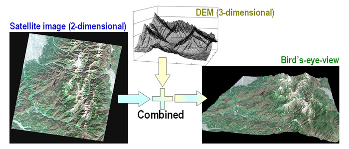
Concept of ASTER G-DEM development |
|||||||||||||||||||||||||||||||||||||||||||||
| Format of ASTER DEM | |||||||||||||||||||||||||||||||||||||||||||||
*Here is the ASTWBD format. |
|||||||||||||||||||||||||||||||||||||||||||||
| Comparison with other DEMs | |||||||||||||||||||||||||||||||||||||||||||||
*SRTM3: Shuttle Radar Topography Mission Data at 3 Arc-Seconds |
|||||||||||||||||||||||||||||||||||||||||||||
Comparison between ASTER GDEM and SRTM3 |
|||||||||||||||||||||||||||||||||||||||||||||
| Distinction from ASTER Level4Z DEM | |||||||||||||||||||||||||||||||||||||||||||||
ASTER Level4Z is provided for a given square of approximately 60 x 60 km corresponding to the scene acquired by ASTER. In contrast, ASTER GDEM is developed based on a grid of 1 x 1 degree in latitude and longitude and requires no scene selection or mosaicking. |
|||||||||||||||||||||||||||||||||||||||||||||
| About "ASTER" , an earth observing satellite sensor |
|---|
| What is ASTER?: ・An achievement from an international joint project between the Ministry of Economy, Trade and Industry of Japan (METI) and the National Aeronautics and Space Administration (NASA) ・An earth observing sensor developed in Japan to be onboard the satellite "Terra" ・In stable operation for more than 9 years since its launch in December 1999 |
What ASTER tells us:
 1) Surface condition
The sensor comprehensively captures spectral ranging from visible to thermal-infrared (invisible to the human eye), and offers detailed information on earth surface conditions (e.g. vegetation, geological features) together with their distribution. 2) Surface temperature Distribution of surface temperature can be observed by the thermal infrared sensor. This will be helpful to detailed studies of such phenomenon as the urban heat island effect. 3) DEM DEM is generated from a stereo-pair of images acquired with nadir and backward angles over the same area. ASTER GDEM will be developed based on this data. |
| Reference about ASTER ASTER Science Project |


