The major characteristics of JERS-1 SAR.
| Synthetic
Aperture Radar [SAR] |
Å@Å@Swath width | 75km |
|---|---|---|
| Resolution | Å@Å@18m x18m | |
| Off-nadir angle | Å@Å@35 deg. | |
| Frequency | Å@Å@1275MHz | |
| Polarization | Å@Å@H-H |
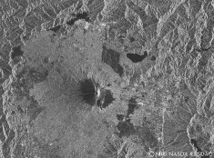
The following is an example of SAR images from Mt.Fuji and surroundings.
The data is processed and analyzed by ERSDAC.
(Click the JPEG-image, then expand to GIF:1152x853pixels, 1136kB)

JERS-1 SAR image
Observed Date: April 23, 1992 Path
065-Row 241 (Mt. Fuji)
Mt.Fuji is standing in the center of the image.
The five lakes surrounding Mt.Fuji and Lake Ashinoko
(in Mt.Hakone, south-east corner of the image)
is seen in black because water does not scatter radar waves.
The grassland of Fuji military fields are shown as relatively dark.
The areas covered by JERS-1 SAR observations data (11.Feb.1992~12.Oct.1998), are shown in blue.
If you wont to look the map more detail, Please click it.